Wednesday, July 28, 2010

7/25/2010 Mackinac Island


Many of you will recognize Larry and Beth, they were our hosts in Hessel and are standing in front of some of the blooming gardens on the grounds of the Grand Hotel on Mackinac Island.

On this glorious day we boarded a ferry boat at St Ignace for the 18 minute ride to Mackinac Island. We passed the Mackinac Bridge which is the 6th longest suspension bridge in the world and links St Ignace with Mackinac City.
Arriving on Machinac was like another trip back in time. No vehicles allowed except a fire truck, public utility truck and ambulance and no where to be seen. Horses, carriages, bikes and walking are the only approved mode of transportation It's history dates back to the fur traders of the 1600's and it's name means "Great Turtle". Fort Mackinac, built in 1780, became a frontier outpost when the English moved the old French garrison on the mainland to the more strategic island. It remained the stronghold of the Straits of Mackinac for 115 years.
This is just a small representation of the bicycles around town. Yummy fudge! To wear of some calories the entire island, just 3 miles by 2 miles and can be navigated by bike in a few hours, viewing ravines, natural bridges, caves and strange rock formations.

The first thing ferry passengers spot as they approach Mackinac Island is the rambling white Grand Hotel, perched atop a hill sheathed in green lawns and untold thousands of blooming flowers. It has 380 rooms, none of which are alike and is touted to be the largest summer resort in the world. It's 660 foot-long pillard veranda is a splendid location to watch sunsets over the blue waters of the lakes...........and the journey continues


7/22 - 7/27/2010 Sault Ste. Marie and Hessel, MI


After departing Marquette we head east to the the town of Hessel and a boat ride to Marquette Island, one of 36, of the Les Cheneaux Islands in Lake Huron. We pass through the areas where the fur traders and Indians co-existed for over a 100 years. Eventually the lumber and raw material industrialists transformed the region to a very prosperous area (at least for some ).

Here we're at one of the shipping locks at Sault Ste. Marie, pronounced " soo"! By any other name the locals will look at you a little suspect. This is the passage from lakes, Michigan and Huron. The ship pictured here is only 600 feet but the locks can handle up to 1000 feet and one is under renovation to handle longer ships. The locks allow vessels of many types to safely traverse the 21' drop of the St. Marys River between the lakes. More than 11,000 vessels pass each year.


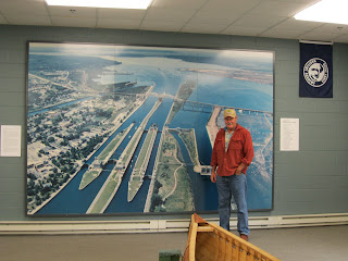
Here Carl stands in front of a picture of the locks. After the tour we dine at old "bar" called the Antlers. It dates back to the earliest days in the era where whiskey was traded for a fur or whatever. It survived prohibition by selling lemonade and ice cream, only to adults. The Feds went after them when they only reported 1 gallon per month sales of ice cream with a $900 profit. Many movie scenes shot here in the bar with all the antlers and stuffed animals, animal heads and birch bark Indian canoes hanging from the rafters. Gunsmoke was a popular shoot. We can visualize Matt and Kitty at the bar.


At the quaint village of Hessel, on the north shore of Lake Huron we meet our friends from Auburn for the boat ride. Their family ties date back 60 years from when they purchased the property from an older family who built it in the 1800's. With one main lodge, pictured, and at least 8 other sleeping quarters this was a summer family retreat and a family museum with handmade tables, chairs, lamps and artifacts the adults played with as children. We are very fortunate to have this experience, but mostly we enjoyed kicking back and enjoying the company of friends.


If you ever needed to sit and meditate, write a manuscript or just let your mind wander, this is it. Down the path is the boat dock, the only way in or out. Tomorrow the four of our going to Mackinac Island...........and the journey continues


Tuesday, July 27, 2010

7/19 - 7/22/2010 Marquette to Hessel


Arrived at the RV Park in Marquette, Michigan "Yooper Penninsula" next to Lake Superior, aka Gitchie Gumee run by Ranger Jeff, a dropout from the 60's! He's devoted his last 30 years to create a master community for a wonderful camp experience. Lots of his own sculptures and Indian collection and lore. Turns out he was once the ski director for Jackson Hole, WY for many years. We really enjoyed his camp.


With the weather so great we found the Northern Michigan University golf course just down the road and headed there for a nice round of chasing golf balls. Fortunately the first ball ended up in the rough which turned out to be fields of blue berries. Priorities got a little mixed and we were as successful gathering these delecious treats as golf.


A nice side trip took us to the Apostle Islands on Lake Superior. They are a national park but only assessable by a tour boat. Fortunately we arrived too late to catch a ride and just enjoyed a very quaint seaport village, called Bayfield. Nice lunch and some more wandering through rural farmlands. We seem to find the local flavor more engaging than the featured parks as we have seen many times the geological formations touted by the parks. Not to minimize the parks but their human surroundings are are also treasures.

Wednesday, July 21, 2010

7/17 - 7/19/2010 Minn, Wisc


Departing St. Paul, we travel through Stillwell, the oldest burg in Minnesota, up into Wisconsin through the land of grains and soy and then into dairy lands as seen in this typical picture, and into the north lands. This forested area is mostly birch and pine. We later learned most of the early transportation was by canoes built from birch bark. For over 150 years the fur traders and indians shared this form of travel as they conducted commerce in the fur business.


We settled in Superior Wisconsin for a few days. Traveled to Diluth to see the shipping industry of the great lakes. They have a good history of the lakes including all the hundreds of ship wrecks, most famously the Edmund Fitzgerald, the song made famous by Gordon Lightfoot. The bridge into the loading docks is pictured here. It is quit a landmark, we saw it go up and down for some pleasure craft and the tourist ferryboat.


We traveled 60-70 miles up the north shore of Superior via the scenic route. The views are somewhat shrouded by dense growth but there are many turn outs. Lots of visitors here as this is a weekend. Having seen a representative taste of the north shore we stumbled into a golf course in Two Harbours. Daylight prevails into late evening so 18 holes with views of the lake was in order. Two Harbours actually showed us another example of the American spirit.

The 3m company had set up shop here because they thought the raw materials were available to make a go of it. It wasn't. They didn't give up and found a different type of material more suitable and guess what? Diversity prevailed.

Lili stands on the shore of Lake Superior. This lake is roughly 400 miles long and 160 miles wide. It would fill the Valley in California from Redding to Bakersfield and the Sierra to the Coast range.....................and the journey continues


Monday, July 19, 2010

7/13 - 7/16/2010 Minnesota


We visited aunt Helen Brust Ericson, with daughter Judy Rys and Carl behind. Had never met Judy or sisters before and spent many hours sharing details of the Brust family as Judy and husband John are expert genealogists and have documented the entire family history.
We spent an evening with Judy's sisters and cousins from another Brust sister (Marie Brust Long) Pictured below are cousin Marilyn Long not pictured was Marilyn's brother, Dale, Carl, cousin Joan, husband Warren and cousin Jean, cousin Judy and cousin Carol, Carol's daughter Carolyn and John Rys, husband of cousin Judy. We shared a good old family potluck and celebrated Jean's birthday....................and the journey continues


Saturday, July 17, 2010

7/11-7/12/2010 Minnestoa bound


I couldn't figure out how to fit this picture into the trip until now.....................
On our way out of Wyoming this guy jumped in front of us at a stop sign. We thought he might be going to mower races but we never saw an announcement so we figured it was his form of transportation. Anything goes in WY, eh?


The drive between SD and MN was dominated by corn fields, soy bean fields, ethanol plants, silos and farms. The different shades of green and yellow against the blue sky made the drive most enjoyable. We're keeping our travel days to about 200 miles which allows us time to explore after we set up. While traveling we've been blessed with great weather and what rains, winds and thunderstorms we've encountered haven't affected our plans. While at Carl's cousins house in MN we heard 4 tornados touched down about 20 miles SE of where our rv (Tinker) was parked. That's about a 1000 miles closer than we want to be to one of those wether events......................and the journey continues, yes, "Tinker"


7/9-7/10/2010 Pierre, Corn Palace


This is a bench lunch on the other side of the Missouri in the capital of S.D., Pierre (pronounced peer) in a county park. The biting flys were not anticipated, therefore we were the only ones there. We wanted to see the Capital City Queen, a paddle wheel tour boat but rushed off to escape the bites.


Off to the state capital building we went we were attracted to this stallion statue located next to a lake on the grounds and discovered it's meaning. In 1991 a plane crashed with the Governor and 3 members of the business community and 2 members of the legislature and they all perished. In their honor this "Fighting Stallions" was made. The horses are 10' tall and incredibly detailed. The capital was typically beautiful with marble pillars, floors and tributes to it's founders.


The Mitchel Corn Palace, known around the world as a folk-art wonder was established in 1892 by Louis Beckwith and L.O. Gale to attract immigrant farmers to settle in the area. It's corny motif changes every year, in early summer the process begins with removal of the old grasses and grains. Over the summer, 3,000 bushels of milo, rye, oat heads, and sour dock are tied in bundles and attached. The corn murals have to wait until late summer when the corn crop is ready. Over a half million ears of corn are sawed in half and nailed to the building following patterns created by a local artist. Inside the building is a stunning museum displaying the past years' motifs. Over the years it's moved just 3 times due to new building codes.........and the journey continues


Friday, July 16, 2010

7/9-7/11/2010 Badlands NP, Missouri R.


In this inhospitable region there is a diversity of wildlife: bison, coyote, butterflies, turtles, vultures, snakes, bluebirds and praire dogs and a large community of varied plant life, including the largest mixed grass prairie in the NPS. The badlands are a place of extremes where the living coexist with the fossils of millions of years ago from the bottom of this sea floor.


The Missouri R along the Lewis & Clark Trail in Oacoma is where Lewis & Clark made their first major camp. All rolling grassland hills and the wide river. It's hard to imagine it with no roads and only indians and buffalo.


These ladies on this road less traveled we looking across the road and we noticed one of them facing the other way so we took a picture. There's one in every group.......................and the journey continues


Sunday, July 11, 2010

7/8/2010 Southern Hills Golf Course, Hot Springs, SD


Ah, a walk on a beautiful golf course can do a lot for the soul. Needed a brake from driving around in the car looking for animals, scenes described in the numerous journals we picked up, get some real exercise and see other spectacular views of new scenery.
On the way back to Custer we stopped at Wind Cave National Park and took the tour. It's the 4th longest cave in the world, 132 miles of tunnels on 3 levels all in 1 square mile of itself at 180' below ground level and we were only at the second level! The features of the cave were boxwork, frostwork and popcorn crystal, non of which were captured on camera well enough to include in the blog......................and the journey continues

7/6/2010 Deadwood, Sturgis


Off to Deadwood and Sturgis to experience the old west again. What a disappointment Deadwood was. Nothing but casinos and not a place to park that didn't require feeding a meter, even the cemetery where Wild Bill Hickock is buried wanted an entry fee! Off to Stugis, Harley Davidson motorcycle haven in August. You guessed it, motorcycle memorabilia, t-shirt shops, tattoo parlors and bars with the merchants/owners rubbing their hands together in eager anticipation of the annual running of the Harley's..............and the journey continues.

7/5/2010 Sylvan Lake


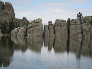
Nestled at the base of Harney Peak and surrounded by impressive rock formations and ponderosa pines, Sylvan Lake is said to be one of the crown jewels of Custer State Park. It's picturesque local begs a stay to be admired and so we did, visiting several times for our walks. Harney Peak, 7242', is the highest point in S. Dakota, not pictured. On a clear day hikers can see all the way from Montana to Nebraska. It is also the highest point in the US east of the Rockies.

7/5/2010 Mt Rushmore


Absolutely remarkabe and symbolic of the principles of liberty and freedom!
We were awestruck at the enormity and creativeness of this monument as well as touched by the reminder of what these men stood for.......and the journey continues


Saturday, July 10, 2010

more July 4 at Custer Museum


Indian bead work for adult and childrens clothes, above and horse blankets to the left made with beads and cotton gotten from european fur traders.


Carl holding court in the judges seat in the courthouse.

July 4, 2010 Custer County Courthouse


Custer County 1881 Courthouse Museum. This building, constructed 8 years before South Dakota became a state, served as the county courthouse until 1973. Displays include American Indian artifacts, photos from Custer's 1874 expedition to keep the settlers out of indian land, gold mining, ranching and industry, the original 1881 courtroom and jail, weapons of the old west, an antique stagecoach and wagons. A note about Custer's expedition: he was sent by the US Gov't to escort squatters off Indian land in the Black Hills. Many of those people ended up filing gold claims and defeating the whole purpose of the mission.


This 1800's clock in the courthouse caught our eye because the top face tells the time of day and the bottom face tells the day, month and year.
The evening was spent watching the towns fireworks display
from our wonderful spot in the parking lot of the Custer hospital. Local knowledge...................and the journey continues

7/2-7/3/2010 Black Hills, SD


JULY 3, HAPPY BIRTHDAY CARL what a spectacular place to celebrate 68 years!

Finding Custer State Park a beautiful 80,000 acre ponderosa pine forest we were hard pressed to decide where to go first so we ventured out on the closest road to our camp. It turned out to be the windiest road in the park. The Needles Highway was constructed to attract tourists in 1932 and was considered an engineering fete.


The Highway threads through 14 miles of oddly shaped, weathered granite spires from which the highway derives its name. One of the more prominent formations is the Needles Eye which stands 30' and has a slit down its center about 3' wide. Several hairpin curves are encountered, as are narrow tunnels, above. The tunnel dimensions are 12' x 8'4" and 12'3" x 9'. This isn't anyplace we'd take our motorhome but we did give way to a tour bus that made it out with it's mirrors in tact! One of the tunnels culminates with a stunning view of Mt. Rushmore..........and the journey continues.


Sunday, July 4, 2010

Cody, WY 6/27-7/2/2010


6/27/28 - So what happened in Cody? A visit to the Buffalo Bill Cody Museum where western adventure history took us. Focusing around Bill Cody, the plains indians, elaborate history of guns and rifles, the Yellowstone experience and wonderful western art in photos, tapestry, paintings and bronze.


6/29 - Golf at Olive Glen, the #3 course in the state per Golf Mag and it wasn't a disappointment. The evening took us to a cowboy music review at the old Cody Theater run by Dan Miller and the Empty Saddle Band. Very entertaining and a must see in our book.


6/30 - Up to Lovell then N into the Big Horn Canyon to search for wild horses and bighorn sheep. This National Forest area if vast with very little impact by people. We spent 5 hours immersed in landscape and watching 2 groups of wild horses & sheep stop what little traffic was there for whatever time you wanted to spend watching. We took way too many photos to put on this blog but will include ones we really liked in the photo end of this blog. At the Big Horn Ranger Station we met the local park geologist who spent an hour with us explaining the age of the canyon and mining ventures around the area, including Bentonite, which we use to clarify some of our wines. On the way out of the canyon we could see big lightning and dark clouds and decided to turn on the AM radio and heard a national weather service warning for the direction we'd planned to take back to camp. Wisely, we took another route! That was a whopper of a T-storm with winds gusting at 40mph. Took in the Cody Night Rodeo to finish the day.


7/1 - Off to Custer, SD through Greybull on Hwy 14, up a 7% grade for 20 miles over Granite Pass at 9,000 ft. with lots of awesome scenery. Picniced at the Burgess Jct. Ranger Station watching Elk graze on the hillside then travelled 8 miles at 8% down. Whew, glad to be off that mountain!


7/2 - Here we are in Custer, SD late and found our accomodations to be more like camping than beeing in a K-mart parking lot. Glad we're here for 7 days.